Showing posts with label fishing. Show all posts

Tuesday, September 3, 2013

The Valley of Life

(Remember that you can click on each image for a larger version.)

When I was at Red River recently, I picked up a map of the Valle Vidal unit of the Carson National Forest. Running through the unit are the Rio Costilla and Comanche Creek, both reputedly chock full of Cutthroat trout. I had also been told I should check out Little Blue Lake. Little Blue is in Rio Costilla Park, which is privately owned by the Rio Costilla Cooperative Livestock Association, and camping access closes to the public after Labor Day. Since August was drawing to a close, I had no time to lose. I packed up the camper and headed north.

I approached Valle Vidal from the east side, passing through the village of Cimarron. The access road is a 30 mile long gravel road, in good shape except for some washboarding. It being a weekday, I saw no one on the way in. This access road passes through part of Ted Turner's Vermejo Park Ranch. You can fish there for $550 per day (guide not included; minimum stay of two nights). Yeah, right. Although I truly appreciate the fact that Ted & Co. are restoring the land and wildlife, it irks me that over a half-million acres are off limits to all but the rich. I have the same ambivalence about all private waters.  Reducing fishing pressure is great, but to do it by excluding the poor is not, IMHO. I'd rather see lower prices and a lottery. By comparison, the cost for camping and fishing at Rio Costilla Park was a bargain; $20 per day to camp and a $7 per day rod fee. The pressure is no doubt higher, but I still had Little Blue lake to myself for about four hours. Not bad. Camping in the Valle Vidal unit runs $12 to $16 per night, and is half-price with the Senior Access card.

Unlike many National Forest districts, Valle Vidal allows no dispersed camping. You must stay in one of two campgrounds; McCrystal or Cimarron. Cimarron is the more popular campground. I opted to stay at McCrystal on my arrival, and only one other campsite out of 60 was occupied that night. It does get more crowded on weekends and during hunting season. The unit also does not allow ATVs. Compared to the Lincoln NF, where I live, and which allows ATVs and dispersed camping, there is a very noticeable improvement in the overall health of the land. Although I would prefer a dispersed camp, I have to admit that this unit's policy has been beneficial.

Here's a view from my campsite at McCrystal. Are those Ted Turner's cattle? I could hear them and coyotes all through the night. The creek is McCrystal Creek. I didn't fish there, but I understand there are some Cutthroats in the creek.

The next day, I headed west through the Valle to Rio Costilla Park. I would return to fish Comanche Creek and the Rio Costilla in a couple of days. After paying the RCCLA fees, I headed up a four wheel drive road to Latir Lakes. These are nine small alpine lakes that had a reputation for holding large cutthroats in the 1980's (including the state record), but there was a die-off and the trout fishing hasn't really recovered since. When I got there, I saw other campers and anglers, so decided to head directly over to Little Blue Lake. I'm afraid I didn't even take any pictures, but the best fishing lake, Latir Lake #3, is a round tree-lined alpine lake, several acres in area.

Little Blue Lake is a tiny alpine lake at an elevation over 11,000 feet and up another steep four wheel drive road. I had the place to myself when I arrived in the late afternoon. The westering sun peeked through the clouds and lit the nearby slopes near the camping area.

The lake is only accessible by foot, down a short trail. I didn't measure it, but I'm guessing it wasn't more than a half mile to the lake. I walked down after setting up camp and cast near the shore where I saw a few rising fish. I caught and released a rainbow, then headed back to camp at sunset.

The next morning, I pumped up the float tube (yes, I remembered the accessories this time - fins, boots, waders and even the PFD), and toted it down to the lake. It was tons of fun kicking around the tiny lake, and if I held still long enough, even caught a few rainbows now and then. They are certainly stocked, although some were large enough to be holdovers. There was a good morning midge hatch, but I don't know if there's diverse enough aquatic life to sustain a large trout population here.

You can see how low the water level was. That's my Creek Co. float tube for scale.  There are two other anglers on the right shore, which also gives an idea of the lake's size.

A Little Blue Lake Rainbow


After lunch back at camp, I packed up and headed back down the four wheel drive road to Midnight Creek. There are designated campsites spread along the creek, so although there is no dispersed camping, you still get some privacy. I picked out a campsite where I could enjoy the creek.

Camp at Midnight Creek, just before the rain started.

Midnight Creek

I fished the creek a little, but had no luck. There are trout there - Cutthroat or Cutbow. I watched one for a few minutes. It had a perfect lie under a bank with roots arching over it. You couldn't drift a fly near without getting it caught in the roots, but it was along a seam that brought food near. The trout would dart out, snatch a morsel from the surface, and dart back to safety, all in a second. It had a fine home.

The next day I went back to the Valle Vidal unit. I spent the day along the Rio Costilla and Comanche Creek. It was a fine day. There are many trout in these waters, but they are educated. There is a fair amount of fishing pressure, and the trout are hard to fool. I saw trout head for my fly and then veer off on most of my casts. Only when I could pull off a good dead drift did I get a hookup. The type of fly was less important than the presentation. Anything buggy looking seemed to draw their attention.

Small trout, big fly on the Costilla

A little bigger one from a Comanche Creek hole.

Comanche Point, where Comanche Creek joins the Rio Costilla

Looking toward Shuree Ponds.  They are hidden in the distance. The pond levels were low and they were covered with algae. I did not fish there.

Driving over "the Rock Wall" you get a good view of the east half of Valle Vidal. The topography is less dramatic looking east, because the start of the Great Plains is not too far away.

Back at McCrystal camp, I took the short hike over to the Ring Ranch, which was active from the 1890s into the first half of the 20th century. It is now part of the Valle Vidal unit of the Carson NF.  In 1890 Timothy Ring bought 320 acres for $3 per acre and started a cattle ranch. The ranch house is slowly being restored. The Ring family had seven daughters, and built on to the house until it had ten bedrooms.  I'll bet it was a popular place with the local cowboys.

Baldy peak from the Ring Ranch

Baldy had a rip-roaring mining history.

The next day, I headed home. As I was driving back on the gravel road toward Cimarron, I stopped to take this panorama of the "Rock Wall" that separates the east side of Valle Vidal from the west, and bid a fond farewell to the Valley of Life. 

If you like fly fishing, be sure to keep this beautiful place on your list.

Monday, November 12, 2012

Agua Chiquita

I took a drive down FS 64 in the lincoln National Forest to see how Agua Chiquita was doing in this prolonged drought. This rito has a two mile stretch that is designated as a wildlife improvement area, and funds from several sources (including Trout Unlimited) have been raised to introduce Rio Grande Cutthroats there.

The road is one of the best maintained gravel roads in the Lincoln NF.  It sees a lot of traffic, since it passes through the tiny villages of Sacramento and Weed. It was also chock-a-block with hunting camps, since there were 1,500 deer permits issued in the Lincoln for November 10-14.

Before dropping down into Agua Chiquita Canyon, you drive through the Scott Able fire burn scar. This fire occurred in 2000, and more than a decade later, the main vegetation is still just grasses.

Scott Able burned areas


This was the first big fire I experienced after moving here. It roared down the canyon in one night, reaching Sacramento and Weed and burning homes. It didn't get much press because it happened at the same time as the big Cerro Grande fire that burned neighborhoods in Los Alamos. I remember watching the smoke and flames from Apache Point Observatory that first night.


The drought has hit Agua Chiquita pretty hard. The protected area is the only section with any water  until you get close to where Agua Chiquita joins with the Rio PeƱasco (all private land).  The protected area is fed by two springs. I can't imagine it will be able to support too many trout. Still, it is a pretty area, even when the grass is dry and the stream is iced over.


Thursday, September 27, 2012

Jack's Creek Campground and the Pecos Wilderness

I had many reasons to head to the upper Pecos: fall colors, full moon, hiking trails into the wilderness and trout. As a bonus, the Pecos River and wilderness are less than one tank of gas from home. Plus, this area was recommended by Argonaut20 over on WanderTheWest. So, on September 27 I headed to Jack's Creek campground to make that my base camp for a few days of exploring. The campground is at the north end of the road that goes up the Pecos Canyon and has trailheads that take you into the Pecos Wilderness.  Even on a Thursday afternoon the campground was about one-third full. I picked a site at the end of the upper loop that offered the most seclusion, and settled in.


The fall colors were not yet at their peak around Jack's Creek.

I hadn't had a chance to camp around full moon in several years. Full moon is less useful time for the astronomy projects I worked on, but it is valuable engineering time, and I always had to be on hand to organize the night-time engineering activities. So, this night I enjoyed being free to watch the moon peek out from behind the clouds that brought a few light rain showers. Unfortunately, my point-and-click camera  could not capture the moonlit landscape.

After a good night's sleep and a leisurely bacon and egg breakfast, Katie-the-collie and I headed down the trail to the Pecos River. We poked around, investigating various pools, and generally enjoying the day. We made it a little way into the wilderness, following the river, until brewing afternoon thunderstorms made us turn back to camp. This trail is a bear highway, based on the amount of scat I saw. I didn't take the fly rod for this hike, but planned to return the day after next.

The Pecos River

A decapitated old puffball along the way

A nice rock outcropping along the Pecos

Looking south down the Pecos Canyon. Storms are brewing.

A little color in the mountains, but some aspens had dropped their leaves before they fully turned color.

Not long after getting back to camp a thunderstorm hit. At first there was a lot of thunder and small hail, then the storm center moved north and there was a steady rain drumming on the camper roof, with thunder in the distance. That was like a narcotic to me, and I drifted into a nice nap until the rain stopped.

Later in the day and into the night the weekend campers started arriving. When I got up the next morning, the campground was almost full. On the plus side, everyone was responsible and friendly. There were no generators running late into the night, and no out-of-control parties.

After breakfast the next day I packed up the daypack and Katie and I headed out on trail 25 into the wilderness. A note for others who plan to hike this trail: there are a few unofficial access trails that go upslope from the upper loop of the campground that will save you up to two miles of hiking outside the wilderness boundary, since the main trail parallels the campground and the trailhead is at the lower end. The unofficial trails look well-used and don't show erosion, so I think they are probably okay to use.

Katie and I followed the trail to Round Mountain, enjoyed the views and wandered around a bit before the afternoon thunderstorms started threatening again.

The wilderness boundary

A view from the shoulder of Round Mountain

A closer view, looking down the Pecos Canyon.

Storms a-brewing

As we headed back, we encountered three different herds of cattle being driven out of the wilderness (yes, the USFS has cattle leases inside the wilderness here). As Katie and I stood off to the side of the trail waiting for one herd to pass, I struck up a conversation with a cowboy. He said the Forest Service was making them drive the cattle out earlier than usual. I asked if that was because they thought it was going to be an early winter. The cowboy shook his head and said he thought it was "just a urinating match" between the Forest Service and the ranchers. His words.  I thought it was odd that they would choose a weekend to drive the herds out, since there were a lot of hikers on the trail. Maybe the cattlemen deliberately wanted hiker conflicts as part of the "urinating  match"? That's pure speculation on my part, though.

My view on the hike back was of a horse's rear end.

The next day, I went back to the Pecos River with my fly rod. There were only a few afternoon clouds and the water was clear, so the trout were in hiding. I'm sure they saw me coming a mile away.  The only luck I had was when a cloud covered the Sun and I drifted a Madam X by an undercut bank. A rainbow darted out and took the fly. It was just a 10-incher, and it released itself while I was fumbling with the camera to snap a picture. You'll just have to believe me. If I said it was a 20-incher, then you would be right to be skeptical. In spite of the slow fishing, it was a glorious afternoon on the Pecos River and I didn't get back to camp until a little after sunset. I'll bet the fishing picked up at sunset, but I didn't want to hike back in the dark along the bear highway.

A beautiful day on the Upper Pecos.

Hiking back to camp.

When I got back to camp, I was surprised to find that I had the Upper Loop entirely to myself. While I was out, everyone had packed up and left. Well, it was Sunday, so I shouldn't have been surprised. The only sounds that night were from the Black Bear Percussion Ensemble beating out some rhythms at the dumpsters.

The next day, October 1, it was time to clean up around the dumpsters (the bears didn't eat cucumber peelings - interesting), break camp and head for home. But, I heeded Argonaut20's advice and took a detour on the road to Elk Mountain. It's a long drive on a dirt road that was mostly in good shape, but the recent rains created some deep puddles. Still, it was two-wheel drive until near the end of the road. The Elk Mountain summit is 11,400 feet and provides some great views.

Looking east from the summit

Looking northwest - toward the Pecos Wilderness.

Looking south at the aspens showing some color. An old fire came right up to the summit.

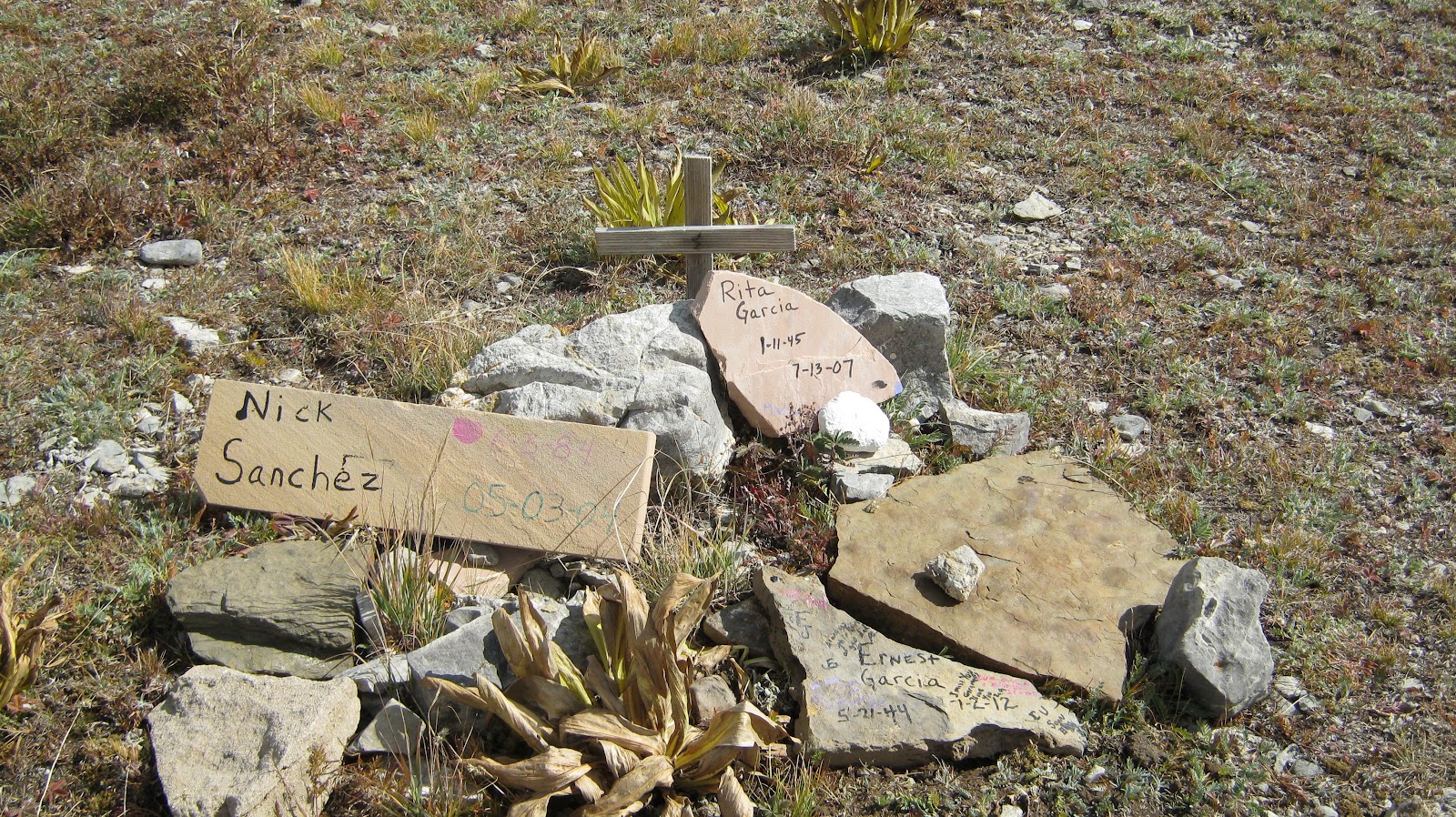
Hey, Argo, do you know anything about this memorial at the summit?

Then, it was time to head south out of the Pecos Canyon, down through Encino, Corona, Tularosa, Carrizozo and Cloudcroft to home. It was a great, relaxing trip and I left plenty of other trails to explore.